Radio Story: Are Houston’s Sinking Suburbs Suffering Worse Flooding?
Note: The following news story aired on the 22 Texas public radio stations affiliated with Texas Standard, including Houston’s KUHF radio.
Listen to the Radio Story: Subsidence and FloodingAfter the flooding last month in Houston, a local geologist noticed something that
looked suspicious: some of the areas of Houston hit hardest were also areas where
the land is sinking. The sinking is called “subsidence.” But there’s a debate over
whether it’s actually making flooding worse.
What made last month’s flooding, especially in north Harris County, so bad?
Simple: a whole lot of rain says Mike Talbott, executive director of the Harris County Flood Control District.
“It has a lot to do with this phenomenal rainfall … people don’t want to talk about the rainfall,” Talbott tells News 88.7.
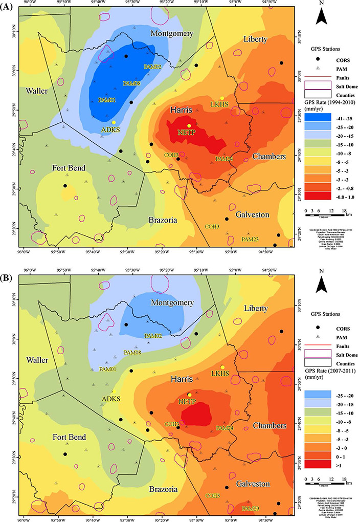
Source: Journal of the International Society for the Prevention of Mitigation of Natural
Hazards
Top map shows worse subsidence in blue since the 1990s. Bottom map shows it moving
northeast in 2011.But people are talking about how other factors, besides the massive rainfall, may
have made things worse. And one those people is a professor of geology at the University
of Houston, Shuhab Khan.
“It’s making it worse,” says Khan.
What Professor Khan believes is making flooding worse in certain neighborhoods is a geological condition Houston and many cities suffer from and have for decades: subsidence. It’s where many acres of ground sink.
Historically in Harris County, subsidence has been worse in areas where over the decades, groundwater and oil and gas have been sucked out from under the ground, causing the land to sink by fractions of an inch a year, in some places by feet over many years.
Could it be that today, the ground that homes are built on is sinking in different places than it did decades ago and thus, could this make flooding worse in places where people say, “It never flooded like this before.”
When Professor Khan looked at maps showing where last month’s flooding damaged the most homes, those maps looked eerily similar to ones he’d drawn as part of a study two years ago, maps showing where subsidence was happening in Harris County.
“Those are the areas that are areas that are subsiding very rapidly. North and northwest. It used to be Jersey Village. (Now) it’s moving northeastwards, north and northeast these days. But it is the same area where the flooding was,” Khan tells News 88.7.
Khan says one subsidence zone is drifting northeast towards the Woodlands and seems to be affected by fault lines that traverse the area. Khan is not saying that subsidence alone is why there’s flooding.
“Of course there would be flooding. But maybe not huge,” says Khan.
At the Flood Control District, Mike Talbott does not agree.
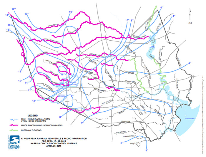
Source: Harris County Flood Control District
Pink shows areas of major flooding April 18th“It’s not subsidence,” Talbott told us. “It didn’t have any role in this event, it
really was about the rainfall. This was phenomenal rainfall that caused some phenomenal
flooding. “
Talbott doesn’t deny subsidence exists. He says the county has been studying it for decades.
“Thirty years ago we got ahead of the curve and went ahead and did a major joint study with a bunch of agencies to understand the phenomenon,” says Talbott.
Talbott says from those studies they learned that where subsidence is occurring in Houston’s northern suburbs, it’s not like a bowl where if your house is at the bottom you’ll be flooded worse.
Instead, he says the sinkage occurs over such a wide area of many square miles that it does not significantly change the depth of the flooding, nor he says will it slow down the flow of creeks in those areas.
“Cypress Creek, the subsidence actually is along the creek, the headwaters subsided nearly the same rate as mouth of the stream so the floodplains would move with the land. You wouldn’t have a change in the flow carrying capacity of the system,” Talbott tells News 88.7.
Put another way, Talbott is saying that even though the northwest suburbs may have sunk a few feet, they’ll still drain just as fast. He says that’s because those suburbs are still about a hundred feet higher than where the water is headed, which is the Houston Ship Channel near downtown.
“The stream just wouldn’t recognize that slight of a change in its slope to really affect the flooding in those areas. It’s a very weak relationship between subsidence and flooding for this region,” Talbott says.
It is a complicated geological occurrence that has a long history of debate, a debate renewed when homes flood and people want to know why.
- Dave Fehling, Texas Standard