Annual Sheriff Lecture
Annual Sheriff Lecture
November 7th, 2016
Hilton Westchase (Google Map Link)
9999 Westheimer Rd, Houston, TX 77042
Speaker: Dr. John Suppe, UH EAS
Lecture Title: The Second Half of Plate Tectonics: Finding the last ~200Ma of subducted lithosphere
and incorporating it into plate reconstruction
Click here for registration and more information (HGS website)
About the Speaker
 Dr. John Suppe, UH EASTomographic imaging is increasingly being used to explore the Earth from the reservoir
scale to the global scale. Here we show that petroleum 3D interpretation, data integration,
and restoration technologies represent powerful resources for making significant discoveries
based on modern tomographic imaging. We illustrated the importance of tomographic
data using examples from
[1] global plate tectonics and [2] the structural geology
of mountain belts.
Dr. John Suppe, UH EASTomographic imaging is increasingly being used to explore the Earth from the reservoir
scale to the global scale. Here we show that petroleum 3D interpretation, data integration,
and restoration technologies represent powerful resources for making significant discoveries
based on modern tomographic imaging. We illustrated the importance of tomographic
data using examples from
[1] global plate tectonics and [2] the structural geology
of mountain belts.
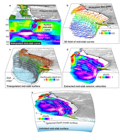 Figure 1 3D mapping and flexural unfolding of the northern Philippine Sea plate Ryukyu slab
(after Wu et al., 2016, Philippine Sea and East Asian platetectonics since 52 Ma constrained
by new subducted slab reconstruction methods. Journal of Geophysical Research 121,
72pp, doi: 10.1002/2016JB012923).
Figure 1 3D mapping and flexural unfolding of the northern Philippine Sea plate Ryukyu slab
(after Wu et al., 2016, Philippine Sea and East Asian platetectonics since 52 Ma constrained
by new subducted slab reconstruction methods. Journal of Geophysical Research 121,
72pp, doi: 10.1002/2016JB012923). 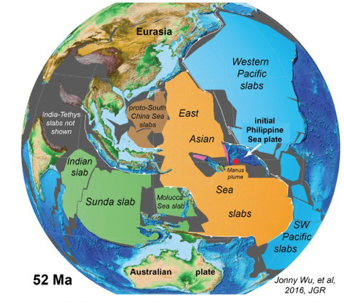 Figure 2 The set of unfolded slabs fit together within uncertainties in picture-puzzle fashion
at time of ~52Ma plate tectonic reorganisation, which marks the initiation of subduction
of the major western Pacific slabs. The now wholly subducted East Asian Sea and South
China Sea flat slabs formed a major ocean between the Pacific and Indian Oceans and
Southeast Asia. The Mesozoic nucleus of the Philippine Sea plate lay near the Manus
plume and the Pacific-East Asian Sea boundary.Precise plate-tectonic reconstruction of the Earth has been constrained largely by
the seafloor magnetic-anomaly record of the present oceans formed during the dispersal
of the last supercontinent since ~200Ma. The corresponding world that was lost to
subduction, which accounts for ~100% of the surface area of the Earth, has been only
sketchily known. We have developed methodologies, largely within a modified Gocad
software environment, to map in 3D these subducted slabs of lithosphere in seismic
tomography and to unfold them to the Earth surface, constraining their initial size,
shapes and locations (Fig. 1). Slab edges are commonly formed at times of plate reorganization
(for example bottom edges typically record initiation of subduction) such that unfolded
slabs fit together in picture-puzzle fashion at times of reorganization, as we illustrate
for the Nazca slab at ~80Ma and the western Pacific slabs between Kamchatka and New
Zealand at ~50Ma (see Fig. 2). Mapping to date suggests that a relatively complete
and decipherable record of lithosphere subducted over the last ~200Ma may exist in
the mantle today, providing a storehouse for new discoveries.
Figure 2 The set of unfolded slabs fit together within uncertainties in picture-puzzle fashion
at time of ~52Ma plate tectonic reorganisation, which marks the initiation of subduction
of the major western Pacific slabs. The now wholly subducted East Asian Sea and South
China Sea flat slabs formed a major ocean between the Pacific and Indian Oceans and
Southeast Asia. The Mesozoic nucleus of the Philippine Sea plate lay near the Manus
plume and the Pacific-East Asian Sea boundary.Precise plate-tectonic reconstruction of the Earth has been constrained largely by
the seafloor magnetic-anomaly record of the present oceans formed during the dispersal
of the last supercontinent since ~200Ma. The corresponding world that was lost to
subduction, which accounts for ~100% of the surface area of the Earth, has been only
sketchily known. We have developed methodologies, largely within a modified Gocad
software environment, to map in 3D these subducted slabs of lithosphere in seismic
tomography and to unfold them to the Earth surface, constraining their initial size,
shapes and locations (Fig. 1). Slab edges are commonly formed at times of plate reorganization
(for example bottom edges typically record initiation of subduction) such that unfolded
slabs fit together in picture-puzzle fashion at times of reorganization, as we illustrate
for the Nazca slab at ~80Ma and the western Pacific slabs between Kamchatka and New
Zealand at ~50Ma (see Fig. 2). Mapping to date suggests that a relatively complete
and decipherable record of lithosphere subducted over the last ~200Ma may exist in
the mantle today, providing a storehouse for new discoveries.
We illustrate our procedure for obtaining slab-constrained plate-tectonic models from tomography with our recent study of the Philippine Sea plate, whose motions and tectonic history have been the least known of the major plates because it has been isolated from the global plate and hotspot circuit by trenches. We mapped and unfolded 28 subducted slabs in the mantle under East Asia and Australia/Oceania to depths of ~1200km, with a subducted area of ~25% of present-day global oceanic lithosphere. We then incorporated them as constraints into a new globally-consistent plate reconstruction of the Philippine Sea and surrounding East Asia, leading to a number of new and unexpected insights, including: [1] discovery of a major (8000 km x 2500 km) set of vanished oceans that we call the East Asia Sea that existed between the Pacific and Indian Oceans, now represented by flat slabs in the lower mantle under present-day Philippine Sea, eastern Sundaland and northern Australia, [3] the Philippine Sea plate collided with the Ryukyu/SW Japan continental margin of Eurasia in arc-arc collision ~20Ma, and [2] the Philippine Sea nucleated as a small trench back-arc system along the East Asian Sea/Pacific boundary, adjacent to the Manus plume, somewhat analogous to the more recent nucleation of the Bismark Sea at the same Manus plume.
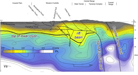 Figure 3 Deep Paleogene rift basins of the south China shelf imaged in seismic tomography
under the Taiwan mountain belt. Allochthonous fragments of these basins are exposed
at the surface in the wastern Taiwan thrust belt. Seismic velocities and Vp/Vs indicate
quartz-rich lithologies.Tomographic images also represent a major driver of new insight into the structure
and tectonics at a finer scale, for example at the scale of mountain belts, particularly
when coupled with the resource of petroleum 3D interpretation, data integration, and
restoration technologies. We illustrate this for the Taiwan mountain belt, which is
an active arc-continent collision. Tomographic mapping has led to the discovery of
deep rift and continental-margins basins underneath the Taiwan mountain belt (Fig.
3) and has illuminated the unexpected ways in which arc-continent collision and flipping
of subduction with reversal of thrust polarity is accomplished in 4D.
Figure 3 Deep Paleogene rift basins of the south China shelf imaged in seismic tomography
under the Taiwan mountain belt. Allochthonous fragments of these basins are exposed
at the surface in the wastern Taiwan thrust belt. Seismic velocities and Vp/Vs indicate
quartz-rich lithologies.Tomographic images also represent a major driver of new insight into the structure
and tectonics at a finer scale, for example at the scale of mountain belts, particularly
when coupled with the resource of petroleum 3D interpretation, data integration, and
restoration technologies. We illustrate this for the Taiwan mountain belt, which is
an active arc-continent collision. Tomographic mapping has led to the discovery of
deep rift and continental-margins basins underneath the Taiwan mountain belt (Fig.
3) and has illuminated the unexpected ways in which arc-continent collision and flipping
of subduction with reversal of thrust polarity is accomplished in 4D.