New Imaging Technology Deployed to Map Well-Exposed Ophiolite in Oman
Mapping Provides Better Understanding of Ocean Crust
 Department of Earth and Atmospheric Sciences (EAS) faculty and graduate students traveled
to Oman in January to test a new type of hyperspectral mapping system that may revolutionize
geological mapping of ophiolites.
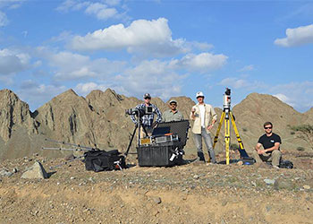
Department of Earth and Atmospheric Sciences (EAS) faculty and graduate students traveled
to Oman in January to test a new type of hyperspectral mapping system that may revolutionize
geological mapping of ophiolites.
Ophiolites are fragments of ocean crust emplaced onto a continent by plate tectonic processes. Mapping them provides a key means of understanding the ocean crust without the expense of a deep sea expedition.
Professors Shuhab Khan and Jonathan Snow and two EAS graduate students spent a week in the Oman ophiolite near the Persian Gulf in the Middle East working with the hyperspectral mapping system. The tool combines visible and near-infrared spectrometry with a GPS-navigated Lidar ranging scanner to produce a 3-D outcrop map, and for the first time, employs a shortwave infrared (SWIR) spectrometer to map minerals present in an outcrop.
These tools are now deployed largely from aircraft and satellites to provide regional scale resolution. This effort in Oman was the first use of these tools at the outcrop scale and will provide much more detailed images that could result in new insights into ophiolites and how they form in oceanic settings.
The work was supported by the EAS department, the College of Natural Sciences and Mathematics, and the University of Houston’s Division of Research.