Project I
Exercise 10 : Plate Tectonics
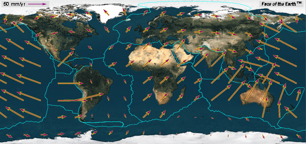
Study the map given above. The longer the arrows (vectors) the higher the velocity of the plate at that geographic point. Look at the arrows along the USA and Canadian boundary. Near the spreading center the North American Plate has a north and west component. In the center of the USA the movement is essentially due west. Near the boundary with the Juan De Fuca Plate the movement is to the south and west. Thus, the direction of motion changes across the North American Plate.
Questions
- If the Atlantic Ocean is widening at a rate of 3 cm per year, how far (in kilometers) will it "open" in a million years? In 200 million years?
For some of the following questions you will need an atlas. The following map may help.
- The Plate Motion Calculator will let you make some calculations that lead to a better understanding of present day plate motion. Use the following data and think about the implications.
- The longitude and latitude of UH are approximately 30 degrees North and 90 degrees west (or 270 degrees East). What is the velocity of the plate at this locality?
Using the calculator enter 30 degrees North (a positive number) and 270 degrees East. Note the convention used by the calculator. You will get two components of the velocity. In this case there is a negative North velocity of -1.62 mm/year and an East veclocity of -12.27 mm/year. What is a negative velocity? If you get a negative velocity then reverse the sense of motion. For Houston, therefore, the velocity is 1.62 mm per year to the south and 12.27 mm/ year to the west. Look at the map. Does this make sense. Clearly, the movement to the west is the dominant component.
- At about 30 degrees North latitude (Houston), the longitude of the mid-Atlantic spreading center is about 45 West longitude (or 315 East). What is the direction of the NA plate at this boundary?
- The western boundary of the NA plate is about 120 W longitude at about 30 degrees N latitude. What are the velocity and direction of the NA plate at this location?
Generalize .... what happens to the direction of the NA plate and its direction of movement going from its eastern to its western boundary at 30 degrees N?
- Santiago Chile is located at 30 degrees S latitude and 290 degrees E longitude. What is the velocity of the South American Plate at this point (remember that a S latitude is entered as a negative)?
- The Juan Fernandez island on the Nazca Plate is located at 30 degrees S latitude and 280 degrees E longitude. What is its velocity?
- The South American Plate and the Nazca Plate are converging. Will the South American Plate "overtake" the Nazca and "sit" on top of the East Pacific Rise? Or, will the distance between the South American Plate and the Nazca Plate increase?
- The faster the spreading rate, the wider the magnetic anomalies. Hot spots (such as the one in the asthenosphere beneath Hawaii) may provide a fixed reference point which can be used to determine absolute motion of the Pacific plate. Ages of volcanism increase to the northwest along the chain. The hot spot is in the asthenosphere and the islands develop in the overlying lithosphere. As the Pacific plate moves to the northwest new lithosphere "sits" on top of the hot spot and a new episode of volcanism is initiated. Follow the chain to the northwest where it becomes the northward trending Emperor seamounts. The "bend" is some 40 million years old. What do you think happened 40 million years ago?
- Hot spots can occur beneath continents and it is proposed that the Yellowstone area in Wyoming sits on top of a hot spot. If the North American plate is moving to the West, where will the volcanism and thermal affects associated with the hot spot be in a million years?
- There are two types of shorelines:
- those that coincide with a plate margin (an active margin) and
- those that don't (a passive margin)
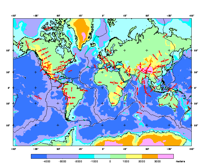
Look at the map of plate boundaries. Describe the southern California shoreline ... the east coast of North America .... the west coast of South America. Comment on potential differences between these two types of coast lines.
There are a number of organizations which focus on Earthquake Hazards and Preparedness .
_________________________________________________________________________________________________
| jbutler@uh.edu
|E-mail the ClassListserv|Read the ClassListserv|
|Textbook Home Page
|Glossary of Geologic Terms|Search These Pages|
|Other Courses|Resources|Grade Book|
_________________________________________________________________________________________________
Return to the Physical Geology Home Page
Copyright by John C. Butler, July 29, 1995