Station 18
Condomania: Variation in Erosion Rates from Station 10 to Station 30.

    The small map that follows shows the locations of these stations along the shoreline near Freeport, Texas.

    The plot that follows uses the 122 year erosion/accretion rates that were used by Morton and Pieper in their 1975 publication.

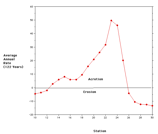
    Note that the area from stations 13 to 25 exhibit a positive 122 year accretion rate. This is the area noted in yellow on the Morton and Pieper map shown previously. Given what you learned about variations in erosion/accretion rates over time at Station 18, it would be wise to extend that analysis to the neighboring stations as well.

    In the following plot the erosion/accreting rates for 78 year interval from 1852 to 1930 and the 26 year interval from 1930 to 1956 are plotted for stations 10 to 30.

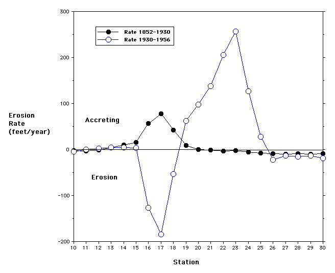
    From 1852 to 1930 this interval of the shoreline was undergoing erosion averaging less than 10 feet per year except for the stations 13 to 20. Note the location of these stations on the map to the right. Multiple choice  

    1. This accreting area is probably the result of deposition of the Old Brazos River Delta.

        True
        False

      From 1930 - 1956 Stations 13 - 18 were undergoing erosion at rates up to nearly 200 feet per year (at Station 17). The region of accretion has shifted to the south.

    2. This accreting area is probably the result of deposition of the New Brazos River Delta.

        True
        False

    In the following figure the rates from the intervals 1930-1956, 1956-1965, and 1965-1974 are plotted versus location. Note that the highest rates of accretion move from Station 23 to Station 24 to Station 25 over time.

    Note that the proposed Condominium Site at Station 18 is within the erosion interval from 1930 to 1974. What do you think may be happening to cause the westward migration of the maximum rate of accretion with time?

    Return