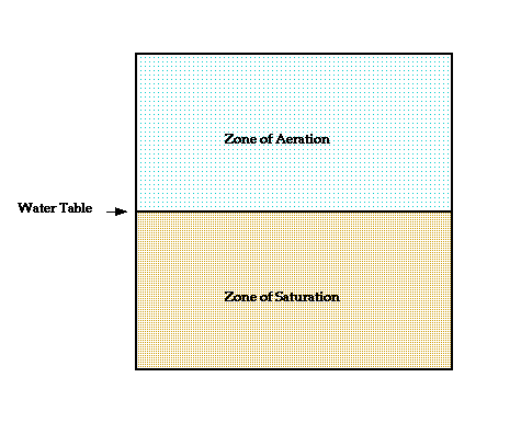
When rain falls, some of the water runs off, some evaporates, and the remainder soaks into the ground. The amount of water that follows each of these paths varies greatly as a function of factors such as:
Some of the water that soaks into the ground adheres to particles in the soil - the belt of soil moisture. Water not held in this belt migrates downward until it reaches a zone in which the pore spaces in the material are completely filled with water - the zone of saturation or the vadose zone. Pores in the overlying zone of aeration are filled with a mixture of air and water. The contact between these two zones is the water table.

Rarely is the water table a flat, planar surface. The water table tends to rise beneath hills and to subside beneath a valley. If water is withdrawn from the zone of saturation at a greater rate than it is replenished, the water table will migrate downward with time. If, on the other hand, the rate of replenishment exceeds the rate of removal, the water table will migrate upwards. If the water table intersects the surface of the Earth, a spring will form.
A small quantity of the water found beneath the water table is juvenile water that has migrated upward from deeper within the Earth. Most, however, originates from the downward migration of rain water.
Tarbuk and Lutgens (1998) estimate that approximately 14% of the fresh water of the hydrosphere is stored as water beneath the Earth's surface.
Minerals vary widely in their chemical response to groundwater. Calcite, for example, is highly soluble in a weak acid such as H2CO3 - carbonic acid. Carbonic acid can form by a reaction between water and carbon dioxide. Rainwater is a weak. Thus, limestones which consist primarily of calcite (CaCO3) are vulnerable to chemical attack by groundwater.
Are You Prepared To Continue?
Caverns
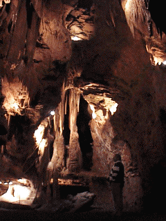
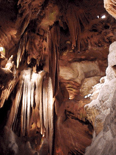
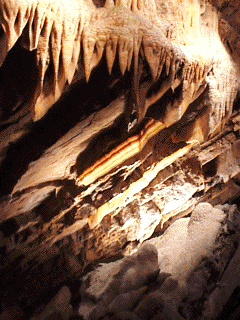
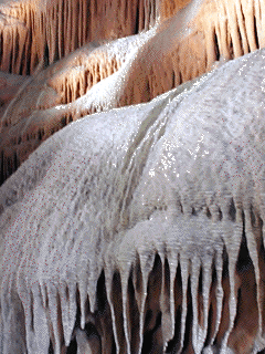
Most caverns are created at or just below the water table in the zone of saturation in limestones. If the water table is stable, large openings can be created by dissolving the limestone. If the water table drops, the area of active cave formation will move lower into the bedrock and the upper openings are abandoned as they are now in the zone of aeration. Water dripping through these abandoned passages may deposit CaCO3 in various forms collectively referred to as speleothems.
| Shenandoah Caverns, Virginia | Cave Formations |
|---|---|
 |  |
| Ribbon or Bacon Rock | Flow Stone |
|---|---|
 |  |
Karst Topography
| Sinkhole Lakes in Central Florida |
|---|
While some sinkholes form slowly by solution of the underlying carbonate rock, other sinkholes develop as a result of the collapse of surface or near-surface material. There are two basic types of sinkhole-forming collapses:
Imagine a situation in which a cavern begins to form at depth. Continued percolation of groundwater through the network of pore spaces or along fractures enlarges the cavern upwards. Eventually the roof of the cavern approaches the surface and a sinkhole may form. Watch the following animation to see one way in which a sinkhole can form.
The Stone Forest is a typical Karst morphological region. Under the controlling geological, hydrologic and climatic factors, the carbonate rock suffered long period of modification, underground and surface water, the present karst morphology in the area was finally formed.
1. Brief Introduction The area known as the Lunnan karst wonder reaches 912km in which the stategic scenic area of state level amounts to 350km . The main scenic areas include the Major, Minor and Naigu Stone Forests, Zhiyun Cave, Jibailong Cave, Qifeng Cave, Lunar Lake, Long Lake and Big Water Fall, etc. The Major and Minor Stone Forests have enjoyed the reputation of the No.1 in the world". Situated in the upper part of purer limestone of the Permian Makou Formation, the rocks there are extremely weirdly shaped, looking like animals or human beings. Those scenic spots are given such interesting names as "birds feeding their young", "phoenix preening itself", "glossy ganoderma of eternity" and so on, making visitors always give full play to their imagination. Being 85km southeast from Kunming City and 15km northeast from Lunan County, they are easily accessible along a second-rank highway. The Naigu Stone Forest, so named because of its weathered black surface ( Naigu means ÉblackÉ in the local ethnic language, Sani), is 9km northeast from the Major Stone Forest. It occurs in dolomite and limestone of Permian Qixia Formation and is uniquely shaped like mushrooms, screen, etc. due to the differential dissolution of different lithologic intercalations. The boundless and blurred "black stone forest" makes for fascinating reverie. The dissolution lakes of enchanting and picturesque scenery, the Lunar Lake and Long Lake as examples, are widespread in the Lunan region. The tempting Big Waterfall is situated in the southeast of Lunan County and 19km away from the downtown area, of which the seat was formed by the erosion along a fault plane of the Baijing River. It flows swiftly over 90m and is the most spectacular waterfall in Yunnan Province. The Lunan underground karsts--karst cave group of Zhiyun Cave, Jibailong Cave, etc. make up another fascinating world, their changeable stalactites make one gasp in admiration. The Shima Dragon Palace, which resembles a fairyland dragon palace, is concealed underground at depths of 100m or more. In particular , a magical scenery named "dragons groaning and tigers roaring" in Qifeng Cave is exactly a natural creation and a true masterpiece of geological agents. People who ardently love the geoscience, paleontology or archaeology can certainly return from a rewarding journey here. There exist the fossils of Mammalia and Chelonia that scatter in 40Mat Lunan red basin. Also the fusulinids that lie in 250Ma are preserved perfectly and concentrated in the groups of the limestone, which is 300m to the east of the Major Stone Forest. So are the brachiopocs faunas of the Middle-Upper Devonian Plectorhychella of the world-wide correlation significance found in Zhaiheidashan. All those are awaiting your investigation and research. 2. Strata and Lithology The main strata in the Stone Forest area include carbonate rock of Qixia Formation and Maokou Formations of Lower Permian, of which the thickness is 505m and which consists of shallow sea platform facies thick layer-massive dolomite, bio-clastic limestone, calcarenite and calcilutite. They were generally believed to include a more pure chemical content in the carbonate rock, which could be more easily dissolved. The limestone in the Stone Forest area has high Cao content which made, along with lower contents of insoluble substance, the karst morphology easier to develop in this area. Most of the carbonate rock in the area are coarsely crystalline and this kind of texture of the rock is easy for dissolution. The lithological assemblage is a key factor for the out look sharp of the carbonate rock of stone forest, and for instance, the thick layer - even content carbonate rock assemblage formed the sharp as sword or pagoda and the interbedded assemblage formed mushroom-like formations. 3. Structural factor Proceeding the karst morphology formation, fault and fracture were the main passageway for the mobilization of surface water and underground water, and the property, density and strike of these fractures obviously controlled the development of the depth, size and direction of karst. Folding and Fault system in the Stone Forest area is not developed. Generally, it is a simply dipping west monocline, attitude of stratum is very flat (2 -6 ) and dipping west. In between the strata, two groups of conjugate shearing joints (NE-SW and NE-SE) are well developed, these joints provide favorable vertical permeable channel and it also controlled the distribution of the Stone Forest. 4. Morphologic and hydrogeologic factors The carbonate rock wide-spread area where distributed east of the Stone Forest and the Stone Forest region belongs to the slope zone of western margin of paleo-level off plane, the topography gently waved from east to west. In this kind of gentle slope topographic condition, the rapid surface runoff can be changed to underground runoff, this is good for the formation of surface and underground karst. The sandstone and shale of Liangshan Formation that is below the carbonate rock formation can be good confining bed in the Stone Forest area, and it controlled the groundwater running from east to west. All genetic factors mentioned above caused the most magnificent karst landscape in the world -the Stone Forest- formed in the distribution area of limestone of Maokou and Qixia Formation of Permian. (Offered by Yunnan Institution of Geosciences, revised by Jack Zhang.)